
Hoi An
Vietnam15.88°N 108.33°E · 13 m
65 places in the index.
15.88°N 108.33°E · 13 m
Ba Be National Park centers on Vietnam's largest natural lake, set within a UNESCO-recognized landscape of towering limestone karsts, dense jungle, and traditional Tay minority villages. The park offers a slower, nature-focused alternative to busier northern Vietnam destinations like Sapa, with kayaking, cave exploration, and village homestays as primary draws.
Atlas entry
Bac Ha is a highland market town near the Chinese border. Its Sunday trade brings together several ethnic communities, with other village markets held through the week.
Bach Ma National Park protects mountain wilderness and cloud forest near Hue. Follow the Five-Lake Cascades Trail or the Pheasant Trail for different views of its habitats.
Ben Tre is a genuine Mekong Delta backwater, separated from bustling My Tho by just 10 km of four-lane highway yet feeling worlds away. Tourists remain scarce and locals are notably open and friendly.
Atlas entry
Buon Ma Thuot is a Central Highlands coffee centre with access to waterfalls and minority villages. Longhouse communities and Lak Lake offer excursions beyond the city.
Ca Mau is the southernmost city of mainland Vietnam, located 350 km southwest of Ho Chi Minh City in the Mekong Delta. The city is characterized by its system of transport canals where most goods arrive by boats and barges.
Atlas entry
Cai Be offers a more authentic Mekong Delta experience than tourist-heavy floating markets further south. The district sits on the northern side of My Thuan Bridge and serves as the gateway into Vinh Long province.
Atlas entry
Cai Rong is a small port town on Van Don island, connected to the mainland by bridge. It serves as the primary ferry departure point for Quan Lan island and the wider Ha Long Bay archipelago.
Atlas entry
Cẩm Phả is a port city on the northeastern coast of Vietnam's Red River Delta. Its non-industrial area is celebrated as one of the 10 most famous landscapes in Vietnam, offering a quieter alternative to the busier tourist hubs in the region.
Atlas entry
Can Tho is a Mekong Delta base for floating markets, canals and pagodas. Start early for a boat trip, then explore food stalls and the cafes around Ninh Kieu Pier.
Cao Bang is a base for limestone caves, mountain lakes and the border waterfall at Ban Gioc. Rural markets and minority villages add cultural interest between landscape excursions.
Cat Ba combines a national park with limestone bays and climbing trips. The island is a base for exploring Lan Ha Bay and its surrounding coast.
The Chàm Islands combine fishing villages, forest and coral reefs off Hoi An. Overnight homestays provide a quieter view of island life after excursion boats leave.
Chau Doc sits at the edge of Vietnam's Mekong Delta where the Cambodian border draws travelers who linger for the atmosphere rather than sights alone. The town fuses Cham, Khmer, and Vietnamese cultures into a place where temple visits blend into riverside strolls and night markets sell grilled river fish alongside incense and electronics.
Atlas entry
Cổ Loa served as the most ancient capital of the Red River delta region, making it a significant site for Vietnamese history enthusiasts. Visits by foreign tourists remain rare, giving the town an off-the-beaten-path authenticity.
Atlas entry
Co To Island is an archipelago in the Gulf of Tonkin with sandy beaches, a lighthouse, forests, and fishing villages. It offers swimming, diving, and rock climbing in a natural setting.
Atlas entry
Con Dao is an archipelago off southern Vietnam known for its natural beauty, with forested hills, deserted beaches, and coral reefs. It has a poignant history as a prison island during French colonial era and the Vietnam War, with preserved prison buildings and a museum.
Atlas entry
Cu Chi preserves an underground wartime landscape near Ho Chi Minh City. Tunnel sections and surviving surface traces explain how people lived beneath the ground.
Cua Ong is a small town in Halong Bay, northern Vietnam. It serves as a possible stopover on the way to Cai Rong, one of the ports that provide access to the islands of Halong Bay, particularly Quan Lanh island.
Atlas entry
Cuc Phuong National Park protects lowland tropical rainforest southwest of Hanoi. Explore trails, visit rescued-wildlife rehabilitation centres and arrange guided bird-watching or night walks.
Da Lat sits in the Central Highlands among pine forests, lakes and waterfalls. Its cooler setting is a base for hiking and cycling as well as visits to pagodas and colonial buildings.
Da Nang is a central-coast city with beaches, Cham sculpture and access to Hoi An and Hue. Combine My Khe Beach with the Marble Mountains and the riverside Dragon Bridge.
Dien Bien Phu is a remote frontier town in northwestern Vietnam, best known as the site of the decisive Battle of Dien Bien Phu in 1954, where General Vo Nguyen Giap's Viet Minh forces defeated the French Union garrison after a 57-day siege. The battle ended major French involvement in Indochina and led directly to the Geneva Accords.
Atlas entry
Dong Ha is the closest major city to the DMZ (Demilitarized Zone), the former border between North and South Vietnam. The city serves primarily as a base for DMZ tours and offers budget accommodation at significantly lower prices than Hue.
Atlas entry
Dong Hoi is a coastal city on the Nhat Le River and a gateway to Phong Nha-Ke Bang. Stay for the beach or use the city as a starting point for cave excursions inland.
Dong Van Karst Plateau Geopark combines limestone cliffs with villages of several ethnic communities. The Ha Giang Loop and the cliff-cut Sky Path offer different ways to explore the mountain scenery.
Gia Nghia (pronounced "Zee-on-gee-ah") is a small town in Dak Nong Province where 19 ethnic groups live together, including Ma, M'Nong, Thai, Nung, Tay, Mường, Hmong, and Kinh. Very few foreign travelers make it here, making it an authentic Central Highlands experience with pristine waterfalls, clean streets, and good scenery away from tourist crowds.
Atlas entry
Ha Giang is a northern gateway to limestone plateaus and mountain roads. Tea-growing hills and minority villages add cultural interest around the route.
Ha Tien is a seaside town at the western edge of the Mekong Delta, just 20 km from the Cambodian border. While marketed as a tourist destination, it sees very few western visitors, making it a quieter, more authentic alternative to busier delta towns.
Atlas entry
Haiphong grew as a colonial port handling trade from upriver Yunnan. Look for the reclining shape of Elephant Mountain and the city's tiny chilli-dipped baguettes.
Halong is a practical base for cruises into the limestone bay. Its city beaches, museum and seafood market offer options before or after a boat trip.
Hanoi brings together pagodas, French colonial buildings and street markets. Explore the Old Quarter on foot, stopping for pho or bun cha and a water puppet performance.
Ho Chi Minh City combines French colonial buildings, skyscrapers and museums of the war years. Phạm Ngũ Lão offers a base for hostels, street food, nightlife and trips toward the Mekong Delta.
Hồ Tràm stretches along a coast of casuarina forests and resort beaches. Pair a seaside walk with the mineral springs around Bình Châu.
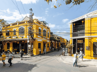
Hoi An is a former trading port with shophouses, lantern-lit lanes and historic assembly halls. Walk through the Old Town, sample cao lau and explore the surrounding countryside by bicycle.
Hue is a former imperial capital with a citadel, royal tombs and pagodas along the Perfume River. Leave time for the historic sites and local dishes such as spicy beef noodle soup and lemongrass pork.
Kon Tum is a relaxed little town with few conventional sights, but its real draw is the surrounding minority villages of the Sedang, Bahnar, Jarai, Gieh Trieng, and Rengao ethnic groups. Each village has a rong, a huge communal house where villagers gather for special occasions.
Atlas entry
Lăng Cô is a fishing and beach town between Hue and Da Nang. Its lagoon and nearby mountain pass create a varied coastal landscape.
Lao Cai is the main overland crossing between Vietnam and China in the north, handling most train traffic between Hanoi and Yunnan Province. Most visitors use it as a transit point en route to Sa Pa or to cross into Hekou, but the town itself offers Cốc Lếu markets with cheap Chinese goods and a relaxed border atmosphere.
Atlas entry
Long Xuyen serves as the capital of An Giang Province in the southwestern Mekong Delta, offering a more authentic Vietnamese experience compared to larger regional hubs like Can Tho. The city is known for its riverside temples, nearby mountain viewpoints, and proximity to Tiger Island, birthplace of Vietnam's second president.
Atlas entry
Mong Cai is a minor border crossing town primarily useful as a transit point between Vietnam and China. Its main appeal is the nearby Trà Cổ Peninsula, which offers one of northeastern Vietnam's few accessible beaches without requiring a ferry.
Atlas entry
Mui Ne stretches along the coast with fishing settlements, resorts and red and white sand dunes. Visit the dunes and Fairy Stream, or budget extra for kite-surfing lessons when the wind suits.
My Tho is the first city in the Mekong Delta that travelers from Ho Chi Minh City reach, making it a convenient gateway for exploring the delta's river islands, floating markets, and waterways. The city serves as a popular launching point for Mekong boat tours, with local operators offering trips to river islands, floating markets, and family-run plantations.
Atlas entry
Nha Trang is a coastal city with an urban beach, diving trips and mud baths. Combine time by the sea with the Po Nagar Cham Towers or an inland waterfall trip.
Ninh Binh’s surrounding countryside combines limestone peaks, waterways and historic temples. Base yourself around Tam Coc or Trang An for boat trips, cave passages and hilltop views.
Phan Rang–Tháp Chàm is the capital of Ninh Thuan province, a former capital of the Cham Empire known as Panduranga. It offers a quieter alternative to Nha Trang to the north, Dalat to the west, and Phan Thiet to the south, with few foreign travelers stopping.
Atlas entry
Phan Thiet is the capital of Binh Thuan province on Vietnam's south-central coast, serving as the administrative and economic hub of the region. The city is best known for its fishing port, traditional whale worship temple, and bustling markets selling fresh seafood.
Atlas entry
Phong Nha-Ke Bang combines caves, underground rivers and forested karst mountains. Phong Nha town offers hostels and tour operators for trips ranging from tourist caves to longer expeditions.
Phu Quoc combines forested hills with beaches and a substantial seafood trade. Its fish-sauce and pepper traditions sit alongside modern island attractions.
Pleiku serves as the capital of Gia Lai province in Vietnam's Central Highlands, offering a refreshing contrast to the coastal tourist trail. The city provides access to ethnic minority villages, serene lakes like Biển Hồ, and colorful pagodas without the crowds of more established destinations.
Atlas entry
Pu Luong Nature Reserve offers a quieter alternative to the more tourist-heavy Sapa region, with fewer visitors and a stronger sense of authentic local life. The area is home to ethnic Thai and Muong communities who maintain traditional farming practices and handicrafts.
Atlas entry
Quan Lạn is a quieter island base in the northern bays. Sandy beaches and a tidal mangrove flat offer a different landscape from nearby forested islands.
Quảng Ngãi is a coastal city with a solemn memorial nearby at My Lai. Beaches and Thien An Mountain offer contrasting excursions around the city.
Quy Nhon combines a city beach and promenade with seafood restaurants and nearby Cham towers. Use the town as a base for coastal villages and the beaches of the Phuong Mai peninsula.
Rach Gia is the capital of Kien Giang province in Vietnam's Mekong Delta. For most tourists it serves primarily as a jumping-off point for trips to Phu Quoc island.
Atlas entry
Sa Pa is a mountain town overlooking terraced countryside in northwest Vietnam. Use it as a base for village walks, homestays and trips into the Hoang Lien range.
Tam Kỳ is Quang Nam state's third city, often bypassed by international travelers in favor of historic Hoi An or cosmopolitan Da Nang. The city has a linear layout stretching along three major roads running northwest to southeast.
Atlas entry
Tây Ninh is the birthplace of Cao Daism and home to its colourful Holy See. Mountain and reservoir excursions add natural scenery around the temple city.
Thac Mo is a seldom-visited town in Binh Phuoc Province, one of the least-traveled destinations in southern Vietnam. The area offers authentic encounters with locals who rarely see foreigners and are genuinely curious and friendly.
Atlas entry
Thái Nguyên is Vietnam's 9th largest city, located about 80 km north of Hanoi, making it an accessible day trip or overnight destination. The city is famous for Tan Cuong tea plantations, Vietnam's first steel mill, and a large university.
Atlas entry
Thanh Hoa is an inland transport centre close to a popular beach and a large national park. Nearby excursions offer more variety than the utilitarian city centre.
Vinh is a railway stop between Hanoi and Hue with a heavily rebuilt urban landscape. Its surviving citadel gates and central square offer a short historical circuit.
Vinh Long is the capital of Vinh Long Province in southern Vietnam, situated on a branch of the Mekong River. It serves as a quieter base for exploring the delta compared to more tourist-heavy destinations like Can Tho.
Atlas entry
Vung Tau is a beach city on a peninsula within reach of Ho Chi Minh City. Explore Front Beach and Back Beach, with hilltop viewpoints and seafood restaurants between them.
Xuan Thuy National Park is Vietnam's first Ramsar site, designated as a wetland of international importance. The park offers exceptional birdwatching opportunities with migratory birds visiting between November and March.
Atlas entry
In development: the whole atlas offline, a trip planner and a private journal. We'll post here when it ships. No newsletter to join.