Abancay
South America · Peru
Did you know?
- The town is a gateway to the Choquequirao trekking route.
- Ampay shelters forests of the native intimpa conifer.
- The Lima–Nasca–Cusco road corridor runs through town.
See also
.JPG)
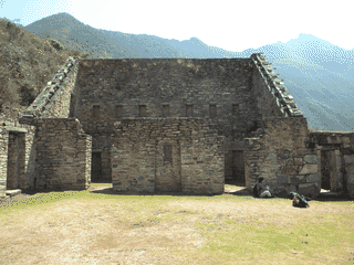
Choquequirao
Peru13.40°S 72.90°W
.jpg)
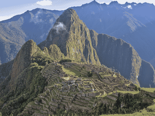
Machu Picchu
Peru13.16°S 72.55°W · 2,430 m
.jpg)
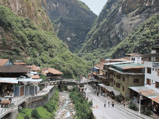
Aguas Calientes
Peru13.15°S 72.52°W · 2,040 m
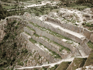

Ollantaytambo
Peru13.25°S 72.27°W · 2,792 m
Maras
Peru13.33°S 72.16°W · 3,300 m
Urubamba
Peru13.30°S 72.12°W · 2,870 m
Overview
Abancay is a practical gateway to the Ampay protected area and the Choquequirao trekking route. Hikers can use the town as a base for exploring the surrounding highlands.
Languages: Aymara, Quechua, Spanish
Why go?
Abancay serves as a practical gateway to the Southern Sierra's high-altitude landscapes, particularly the Ampay protected area and the trekking route to Choquequirao. It offers a quieter, more authentic Andean experience compared to the tourist-heavy hubs of Cusco or Huaraz. The town's compact size and river valley setting make it a manageable base for day hikes and multi-day treks.
Adapted from Wikivoyage contributors · CC BY-SA 4.0
Getting in
The Lima-Nasca-Cusco Interoceánica Sur bus line passes through Abancay on well-paved roads. Daily buses connect to Andahuaylas (5-6 hours on unpaved roads), which hosts one of the closest airports. The closest major airport is in Cusco, reachable by bus (4.5-5 hours) or colectivo (3.5-4 hours).
Adapted from Wikivoyage contributors · CC BY-SA 4.0
Getting around
Distances within Abancay are short, making walking the most practical option. Taxis are available for longer trips or luggage, with fares typically capped at S/3 within the city. For excursions to Ampay, colectivos (shared taxis) like route 2 to Sawanay are the standard local transport.
Adapted from Wikivoyage contributors · CC BY-SA 4.0
When to go
The dry season is recommended for visiting Ampay sanctuary and trekking, as trails become difficult and muddy in the wet season. The town is accessible year-round, but weather conditions significantly impact hiking safety and visibility. Plan around the dry months for the best trekking conditions to Choquequirao.
Adapted from Wikivoyage contributors · CC BY-SA 4.0
Field guide adapted from Wikivoyage contributors · CC BY-SA 4.0. Text has been adapted and organized for this guide. About our sources.
Places to know
A few starting points from the guide. Check current hours and prices before you go.
- sleep
El Dorado
Good and safe budget hotel on Av. Arenas.
Recorded price: ca. US$5
Adapted from Wikivoyage contributors
- sleep
Hotel Paraiso
Across from bus terminal. S/30 for matrimonial with private bathroom, but lacks hot water.
Recorded price: S/30
Adapted from Wikivoyage contributors
- sleep
Hotel Turistas (old hacienda)
Splurge option with hot water and dining-room.
Adapted from Wikivoyage contributors
- sleep
Saywa Hotel
A good value for the price. Nice rooms with real, strong hot water showers, cable TV, and a fast connection of WiFi. Rooms on the front have fantastic views overlooking the park and mountains behind. Price includes breakfast. Price for a single room is normally S/50 per night, but can be talked down to S/40.
Adapted from Wikivoyage contributors
- eat
Avenida Arenas Restaurants
Main strip with diverse restaurants, bars, and a market for fresh produce.
Adapted from Wikivoyage contributors
- eat
Vegetarian Restaurant
Located one block uphill from the main drag, offering vegetarian options.
Adapted from Wikivoyage contributors
- see
AMPAY sanctuary
Protected area with hiking to lagoons and views of Nevada Ampay. Fee S/30 if hut attended. Guide available from municipality for S/30 per day.
Recorded price: S/30
Adapted from Wikivoyage contributors
- buy
Local Market
Market on Avenida Arenas for fruits, vegetables, and local goods.
Adapted from Wikivoyage contributors
Before you go
Accommodation
Budget hotels from S/30 per night.
Connectivity
WiFi is available in some hotels. Mobile coverage may be spotty in the mountains and canyon areas.
Culture
Respect local customs in the Apurimac region. The town is a mix of Spanish and Quechua influences.
Food
Main drag Avenida Arenas has many restaurants and bars.
Health
Altitude 2,378 m – take it easy when arriving.
Local transport
Walking is sufficient for the town center. Use colectivos for Ampay and taxis for luggage or late-night travel.
Money
Carry local currency (soles) for taxis, colectivos, and small vendors. ATMs may be limited or unreliable in the valley.
Safety
Be aware of altitude sickness at 2,378m. Exercise caution on unpaved roads and with unregulated transport options.
Transport
Walking is best; taxis should cost no more than S/3 within city.
Visa context
Visa rules depend on passport; check current entry rules before booking.
Weather
Best visited in dry season for hiking.