Overview
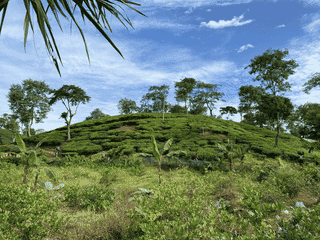
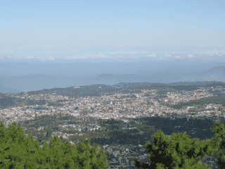
Shillong rises through pine-covered hills at 1,496 metres, with a milder climate and a strong British legacy. Waterfalls, caves, lake activities, and access to Cherrapunji give the city a distinctly outdoors-focused character.
Nature · Mountains · Culture · Museums · Lake
Did you know?
- Umiam Lake offers kayaking, water cycling, and boating on a man-made lake.
- Iewduh is described as one of the biggest markets in North-East India.
- Madras Cafe serves idlis, dosas, and vadas from 7AM–10PM for around ₹100.
Where it is
Shillong is 142 km north of Srimangal.
Why Go
Shillong is the capital of Meghalaya and the largest town in India's North-Eastern states, perched at 1,496 metres above sea level in undulating pine-covered hills. Known as the Scotland of the East, it offers a milder climate than tropical India and retains a strong British legacy in its architecture and food habits. The city is famous for its waterfalls, caves, and as a gateway to Cherrapunji's world-record rainfall. Its predominantly Christian population creates a distinct cultural atmosphere compared to the rest of India.
Getting In
Shillong Airport (Umroi) is about 40 km from the city and handles flights from Kolkata on certain days of the week. An MTDC bus runs between the airport and Shillong market. The city is also accessible by road from Guwahati (approximately 100 km), which is the nearest major railhead and airport hub.
Getting Around
The best way to explore Shillong is on foot. The city is small and can be easily covered by walking, allowing you to explore the hills and interact with locals. Local shared taxis and auto-rickshaws are available for longer distances.
When To Go
The best time to visit Shillong is during the rainy season (June-September) when the famous waterfalls including those in Cherrapunji are in full flow. However, be prepared for heavy rainfall. The post-monsoon months offer clearer skies while maintaining lush greenery. Winters can be cold at this altitude.
Where To Stay
Most hotels in Shillong are concentrated in and around Police Bazar, the noisy crowded city centre. Hotel Polo Towers and Royal Heritage offer more relaxing locations. Budget travelers can stay at the Youth Hostel near the CTO Complex for ₹155 per bed, though it tends to be crowded with 15+ people per room. Mid-range options include Hotel Knight Inn, Hotel Lake View Inn, and Travellers Bed & Breakfast (dorms from ₹300, doubles from ₹950).
Food And Drink
Shillong has a variety of restaurants, mostly in the Police Bazar area, serving Chinese, Indian, and Tibetan cuisine. Must-try items include momos (steamed Tibetan dumplings with cabbage and pork/chicken) available in small and large sizes. Khasi and Tibetan recipes use very little spices and emphasize boiling or roasting over frying. For South Indian food, Madras Cafe in Police Bazar serves idlis, dosas, and vadas from 7AM-10PM for around ₹100 per meal. Vegetarians can try Sharma Bhojanalaya near Police Bazaar for Marwari thali at ₹40. The city is a drinker's paradise due to Meghalaya's low alcohol tax structure, making liquor significantly cheaper than elsewhere in India. Nightlife peaks on Fridays and Saturdays.
Things To Do
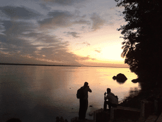
Take a walk through Iewduh (Bara Bazar), one of the biggest markets in North-East India with separate sections for vegetables, fruits, iron works, fish, beef, and betel. Visit the Don Bosco Museum of Indigenous North East Culture, the largest cultural museum in Asia, covering all eight NE states. Explore the forest around Shillong Peak (1,965 metres, the state's highest point) where you can spot the insect-eating pitcher plant (Nepenthes khasiana). Shillong has many beautiful caves to explore. For water sports, head to Umiam Lake (Barapani) 20 km north, a man-made lake with kayaking, water cycling, and boating facilities.
Buy
Iewduh is the largest open street market in north-eastern India, offering local fruits, vegetables, honey, and fish alongside a vivid picture of local life. Traditional bamboo handicrafts and woollen handmade shawls are popular souvenirs. Visit Purbashree, the Meghalaya Government Handicrafts Showroom in Police Bazar for authentic crafts. Shillong is also a fashion capital of India with numerous shops selling top brands at RAPs Apparel (MG Road), Uncle Shop, In-Fashion, Broadway Collection, and Selection Centre.
See
Key attractions include Elephant Falls in Upper Shillong (named by the British for a rock that resembled an elephant, destroyed in an earthquake), the Cathedral of Mary Help of Christians perched on a hill in Laitumkhrah, Wards Lake below the Raj Bhavan with boating and garden walks, and Umiam Lake (Barapani) which resembles Scottish lochs. Sweet Falls in Happy Valley is very steep with no barricades—extreme caution advised. Lady Hydari Park features flowering plants, orchids, a mini zoo, and deer park spread over more than a kilometre.
Safety
Shillong is generally safe for travelers, though standard precautions apply. Be cautious on steep trails like Sweet Falls where there are no barricades and rocks are slippery. During monsoon season, roads to Cherrapunji and other destinations can be affected by landslides. Smaller food outlets may have cleanliness issues.
Connectivity
Mobile coverage is available through major Indian carriers. WiFi is offered at starred hotels and some cafes. India uses Type C, Type D, and Type M power plugs (230V/50Hz).
Budget
Shillong is budget-friendly for India. Dorm beds at Youth Hostel cost ₹155 per night. Budget doubles start from ₹950 at Travellers B&B. Meals at local eateries range from ₹40 (Marwari thali) to ₹100 (South Indian at Madras Cafe). Alcohol is exceptionally cheap due to the state's tax structure. Local transport is affordable via shared taxis and auto-rickshaws.
Day Trips
Cherrapunji (Sohra) is 60 km south, famous for Noh Kalikai Falls and limestone caves with stalactites and stalagmites—best visited during monsoon for thundering waterfalls. Mawsynram, 56 km away, holds a Guinness record for highest average annual rainfall (11,873 mm) and features the Mawjymbuin cave with a Shivalinga-shaped stalagmite. Jakrem, 64 km away, offers sulphur hot springs believed to have curative properties. Sacred Forest (Mawphlang) is 25 km away—dense groves protected for centuries, home to Khasi pines, ferns, and endemic orchids. Umiam Lake water sports complex is 20 km north.
Go Next
From Shillong, explore the rest of Meghalaya: Cherrapunji's waterfalls and caves, Mawsynram's sacred caves, the sulphur hot springs at Jakrem, the protected Sacred Forests at Mawphlang, and Umiam Lake's water sports. Jaintia Hills offers a 700-year-old Durga temple, a lake, and rock garden.
Guide text adapted from Wikivoyage contributors under CC BY-SA 4.0.
Where to start
Sleep
Hotel Alpine Continental
3 star.
Sleep
Hotel Barbareek Inn
Sleep
Hotel Knight Inn Shillong
Also includes Kenmore Restaurant, which serves mouth-watering food from Chinese, Indian and other cuisines.
Sleep
Hotel Lake View Inn
MG Road,
Sleep
Hotel Polo Towers
Shillong`s only 4-star hotel.
Sleep
Hotel Rainbow Shillong
GS road Police bazar
Sleep
Hotel Yalana
Laimukhra.
Sleep
Ri Kynjai - Serenity By The Lake
very resort-like.
Before you go
Connectivity
Major Indian mobile carriers provide coverage. WiFi at hotels and some cafes. India uses Type C/D/M power plugs (230V/50Hz).
Drink
Meghalaya has low alcohol taxes—cheapest drinks in India. Nightlife peaks Fridays and Saturdays. Pubs include Cloud 9, Polo Irish Pub, and Tango.
Food
Khasi and Tibetan cuisine uses less spices than rest of India. Try momos, local fruits, and bamboo shoot pickles. Beef less common due to Christian population.
Money
India uses Indian Rupees (INR/₹). ATMs are available in Police Bazar area. Credit cards accepted at starred hotels and some restaurants.
Safety
Generally safe for travelers. Caution on steep trails without barricades. Landslides possible during monsoon on roads to Cherrapunji.
Transport
Shillong is best explored on foot. Shared taxis and auto-rickshaws available for longer distances. MTDC bus connects airport to city.
Weather
Best visited during rainy season (June-September) for waterfalls in full flow. Milder climate than tropical India due to altitude of 1,496 metres.