
Lake Atitlán
Mexico, Central America and the Caribbean · Guatemala
Did you know?
- Maya languages, traditional clothing and farming remain part of everyday village life.
- A prehistoric volcanic caldera holds the water.
- Dive trips are arranged through La Iguana Perdida hostel.
See also
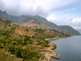

Santa Cruz la Laguna
Guatemala14.74°N 91.21°W · 1,832 m
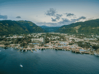

Panajachel
Guatemala14.74°N 91.16°W · 1,597 m
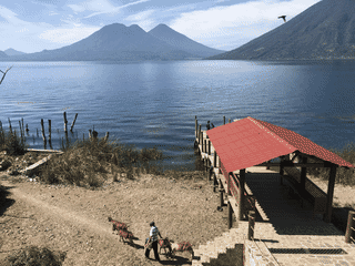

San Marcos La Laguna
Guatemala14.72°N 91.27°W · 1,460 m
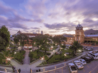

Solola
Guatemala14.77°N 91.18°W · 2,114 m
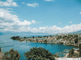

San Pedro la Laguna
Guatemala14.69°N 91.27°W · 1,610 m
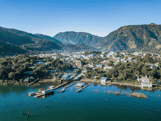

San Juan
Guatemala14.70°N 91.28°W
Overview
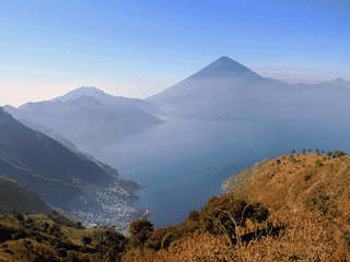
Lake Atitlán fills a volcanic caldera in Guatemala's Western Highlands. Its lakeside towns offer Maya culture, artisan traditions, retreats and backpacker hangouts.
Languages: Spanish
Why Go
Lake Atitlán is a breathtaking volcanic caldera lake in Guatemala's Western Highlands at 1562 m altitude, often called the most beautiful lake in the world by explorers like Alexander von Humboldt. The region combines scenic beauty with accessible Mayan culture, relaxed atmosphere, and solid backpacker infrastructure. Ringed by small towns including the backpacker hub San Pedro La Laguna, the meditation-focused village San Marcos, and the artisan-rich San Juan la Laguna, it offers diverse experiences from party scenes to spiritual retreats.
Adapted from Wikivoyage contributors · CC BY-SA 4.0
Understand
Lake Atitlán sits in a prehistoric supervolcano caldera, with the Tolimán volcano (3158 m) at its southern end and maximum depth of 340 m. Three volcanoes frame the southern flank, creating mirror-like reflections on the lake's surface. Indigenous communities maintain traditional farming methods, syncretic religions, and many people speak their own Mayan languages rather than Spanish. Women and occasionally men predominantly wear traditional outfits rather than Western clothing, particularly outside the main tourist centers.
Adapted from Wikivoyage contributors · CC BY-SA 4.0
Get In
Most travelers arrive in Panajachel, the most accessible town on the lake. Bus and transportation details are covered in Panajachel's article. Less-frequent buses run to some other towns. Tourist shuttles connect Antigua Guatemala to San Pedro la Laguna and San Juan la Laguna. Public boats travel along the northwest shore between Panajachel and San Marcos, making lakeside hotels accessible.
Adapted from Wikivoyage contributors · CC BY-SA 4.0
See
The lake itself is arguably the most beautiful place in Guatemala, acting as a giant mirror to the three surrounding volcanoes. The Indian's Nose/Rostro Maya is a popular hike to a viewpoint above San Juan and San Marcos villages, accessible via various tracks or organized horse trips. The main attraction is experiencing thriving Maya communities where indigenous languages are spoken, traditional farming persists, and traditional clothing is worn daily—best observed outside the main tourist centers of Panajachel, San Pedro, and San Marcos.
Adapted from Wikivoyage contributors · CC BY-SA 4.0
Do
Activities include hiking, volcano tours, bike tours, village tours, coffee tours, birdwatching, lake treks, kayaking, and cultural tours. Kayaks can be rented from Casa del Mundo in Jaibalito or in San Pedro la Laguna. Diving is available through La Iguana Perdida hostel in Santa Cruz la Laguna. A circuit path encircles most of the lake, though new developments have restricted some access. Climbing the three volcanoes is popular: San Pedro volcano costs Q100 when guided from San Pedro, while Atitlán and Tolimán can be arranged from Panajachel. Independent hikes cost under Q200 (approximately US$24), mostly park entrance fees and boat fare. The easiest approach is biking or renting a motorcycle from Pana, or taking a boat to Santiago then a pickup to San Lucas.
Adapted from Wikivoyage contributors · CC BY-SA 4.0
Eat
Towns around the lake have restaurants at various price points from luxury to budget. Street food is more common in larger towns. Local food like dobladas, garnachas, tostadas, empanadas, and pupusas are found especially in less touristy areas. Prices at casual shops and bakeries vary widely—muffins can cost as low as Q2.5 (July 2024), though many vendors ask Q5 from tourists. Pizza, hamburgers, and questionable Mexican food cater to those seeking junk food.
Adapted from Wikivoyage contributors · CC BY-SA 4.0
Drink
Lake Atitlán is better for relaxation than partying. Panajachel and San Pedro la Laguna have thriving bar scenes, while other towns quiet down after dark.
Adapted from Wikivoyage contributors · CC BY-SA 4.0
Sleep
Each town and village around the lake offers a wide range of hotels. Many hotels now line the lakeside between towns, especially along the northwest quadrant accessible via public boats between Panajachel and San Marcos. Notable options include Lomas de Tzununá perched on the hillside between Santa Cruz la Laguna and San Marcos, and La Riviera de Atitlán, a high-end resort west of Panajachel on San Buenaventura bay. See individual town articles for specific accommodation details.
Adapted from Wikivoyage contributors · CC BY-SA 4.0
Stay Safe
Crime is minimal within towns and on boats—take normal theft precautions. However, parts of ring trails and volcano hikes carry armed robbery risk as of July 2024. Inquire carefully before walking trails, especially without a local guide. The road between San Juan and San Marcos has had daytime violent crime including robberies and rapes (2004 reports). The road from San Lucas Tolimán to Cerro de Oro is now considered safe. The road from San Marcos La Laguna to the next northern village is controlled by Tourist Police, but walking with backpacks or large sums of money is not recommended. Hiking in mountainous areas around San Marcos is not recommended due to known thieves with limited police control—explore in groups of three or more, or carry nothing of value if alone.
Adapted from Wikivoyage contributors · CC BY-SA 4.0
Go Next
From Lake Atitlán, travelers can continue to the Pacific Lowlands or Central Highlands of Guatemala. The region is part of the Western Highlands, providing connections to Antigua Guatemala via tourist shuttles.
Adapted from Wikivoyage contributors · CC BY-SA 4.0
Field guide adapted from Wikivoyage contributors · CC BY-SA 4.0. Text has been adapted and organized for this guide. About our sources.
Places to know
A few starting points from the guide. Check current hours and prices before you go.
- sleep
La Riviera de Atitlan
A high-end resort, a few kilometers to the west of Panajachel on the bay of San Buenaventura.
Recorded price: US$150/night
Adapted from Wikivoyage contributors
- sleep
Lomas de Tzununá
A place perched on the hillside between Santa Cruz la Laguna and San Marcos (Guatemala)
Adapted from Wikivoyage contributors
- see
Indian's Nose/Rostro Maya
Popular viewpoint hike above San Juan and San Marcos villages
Adapted from Wikivoyage contributors
- do
Diving at La Iguana Perdida
Diving opportunities through this hostel in Santa Cruz la Laguna
Adapted from Wikivoyage contributors
- do
Kayaking at Casa del Mundo
Kayak rentals at this lakeside spot near Jaibalito
Adapted from Wikivoyage contributors
- do
Lake Circuit Path
Rewarding hike encircling most of the lake, though some sections restricted by new developments
Adapted from Wikivoyage contributors
- do
San Pedro Volcano Climb
Guided volcano climb from San Pedro village
Recorded price: Q100
Adapted from Wikivoyage contributors
Before you go
Culture
Many indigenous communities speak Mayan languages and wear traditional clothing. Respect local customs and dress modestly, especially in rural areas.
Health
Altitude of 1562 m may affect some travelers. The lake is volcanic with depths up to 340 m. Swimming is possible but be aware of boat traffic.
Money
Local currency is the Guatemalan quetzal (GTQ). Prices vary widely—muffins can cost Q2.5-Q5 depending on vendor. Volcano hikes cost under Q200 independently.
Safety
Armed robbery risk exists on some ring trails and volcano hikes. The road between San Juan and San Marcos has had violent crime. Hike in groups and avoid carrying valuables.
Transport
Public boats travel along the northwest shore between Panajachel and San Marcos. Tourist shuttles connect Antigua to San Pedro and San Juan.
Weather
Lake Atitlán sits at 1562 m altitude. Weather is cooler than lowland Guatemala. Bring layers and be prepared for temperature changes.