Overview
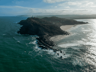
Cape Byron State Conservation Area marks the easternmost point of the Australian mainland, making it a symbolic must-visit for travelers seeking to stand at the continent's edge. The area features Australia's most powerful lighthouse, built in 1901, which draws more than 500,000 visitors annually with its 2,200,000 candela light intensity.
Beach · Day Trips · Nature · Transit Hub · Trekking
Before you go
Connectivity
Mobile coverage available from Byron Bay networks. WiFi available at the Cape Byron Information Centre during operating hours.
Money
Parking fees are $8/hour for cars and $4/hour for motorcycles at the lighthouse lawn. $4/vehicle/hour at lookouts. Cash or card at self-service machines.
Packing
Walking shoes for the Cape Byron Walking Track, sunscreen, water, camera, and light jacket for windy afternoons. Rain jacket for April.
Safety
Walk carefully on narrow Lighthouse Road if approaching on foot. Drink spiking reported in nearby Byron Bay—never leave beverages unattended.
Transport
Access via Lighthouse Road from Byron Bay, 3-minute drive or 30-minute walk. No public transport within the park. Nearest airport is Ballina/Byron (BNK) with shuttle to Byron CBD.
Weather
Coastal climate with mild temperatures year-round (19-28°C). Driest month is September; wettest is April. Afternoon winds common outside summer—bring a light jacket.