
Royal Natal National Park
Africa · South Africa
See also

Maseru
Lesotho29.31°S 27.48°E · 1,600 m
Overview
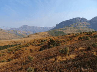
Royal Natal National Park sits in the Maloti Drakensberg Park World Heritage Site, centered on the dramatic Amphitheatre cliff face—a 5-km wide wall of basalt rising nearly 1,200 m above the valley. The park contains Tugela Falls, which at 983 m total drop ranks as the world's highest waterfall by some measures.
Languages: Afrikaans, English, Southern Ndebele, Northern Sotho, Southern Sotho, Swazi, Tswana, Tsonga, Venda, Xhosa, Zulu
Why go?
Royal Natal National Park sits in the Maloti Drakensberg Park World Heritage Site, centered on the dramatic Amphitheatre cliff face—a 5-km wide wall of basalt rising nearly 1,200 m above the valley. The park contains Tugela Falls, which at 983 m total drop ranks as the world's highest waterfall by some measures. Hikers come for well-marked trails ranging from easy walks to challenging multi-hour treks, while the remote setting and limited light pollution make it a dark-sky destination. Unlike the busier Golden Gate area further south, Royal Natal remains relatively uncrowded even during school holidays.
Adapted from Wikivoyage contributors · CC BY-SA 4.0
Getting in
From the N3, take exit near Ladysmith onto R616 towards Bergville (35 km). At the R74 junction, turn right and follow 29 km to join R615, then turn left for the final 19 km into the park. A more scenic alternative from Harrismith: exit N3 at Harrismith onto N5 east for 5 km, turn left onto R74 and follow 38 km before joining R615. Drive carefully on R615 as it passes through rural villages where livestock and school children cross roads at will. The nearest petrol station and tyre repair is in Bergville, 48 km away. Entrance hours are 6AM to 10PM (May–Sep) and 5AM to 7PM (Oct–Mar); residents may enter 24 hours.
Adapted from Wikivoyage contributors · CC BY-SA 4.0
Getting around
The park speed limit is 40 km/h, but most visitors leave their vehicles to hike. A small shop at the Information Office (first building on the left after the gate) sells basic supplies including washing powder, ice, boerewors, beer (R15, 2018), curios, and maps. A mini-ATM behind the Information counter provides cash in exchange for a slip at the counter. Fuel is unavailable in the park; refill before arrival in Bergville or Harrismith.
Adapted from Wikivoyage contributors · CC BY-SA 4.0
When to go
Late summer (March to May) offers the best conditions: rivers are full from summer rains, air is crystal clear, and vegetation is lush green. The rainy season runs October to March, typically as short afternoon thundershowers that can interrupt hiking. Winter (April to September) is dry but windy, particularly in late winter. Snow is possible June to August, occasionally closing high passes. Summer hikers should start early to avoid afternoon storms and thick mist that makes navigation on exposed ridges hazardous.
Adapted from Wikivoyage contributors · CC BY-SA 4.0
Where to stay
Royal Natal offers five accommodation tiers within the park: Lower Camp has 8 two-bed and 5 four-bed self-catering chalets with kitchen and bathroom; Upper Camp provides 6 two-bed and 7 four-bed chalets with separate lounges; Cottage offers two six-bed units with three bedrooms and full kitchen; Thendele Lodge accommodates six guests in three en-suite bedrooms with cook available; Mahai Camp has powered and unpowered sites from R65 per night with clean ablutions, laundry facilities, and 24-hour security. Witsieshoek Mountain Lodge outside the park near Clarens is the closest option for Sentinel Peak hikers, accessible only by 4x4 with shuttle service available.
Adapted from Wikivoyage contributors · CC BY-SA 4.0
Food and drink
The park shop at the Information Office stocks essentials including bread, eggs, meat, beer (R15), soft drinks, and basic camping supplies—adequate for self-catering but not for extended stays without a resupply trip to Bergville. The nearest towns with supermarkets and restaurants are Bergville (45 km) and Harrismith. Boerewors (spiced sausage) sold at the shop is a local specialty best grilled at your campsite. All accommodation is self-catering; bring all specialty items as the shop selection is limited.
Adapted from Wikivoyage contributors · CC BY-SA 4.0
Things to do
The Amphitheatre is the park's signature sight, visible from most viewpoints but best appreciated on the 23-km Gorge walk which takes 5-6 hours. The Sentinel/Tugela Falls Walk (6-7 hours) reaches the top of Africa's highest waterfall via two sets of exposed ladders; an early summer start is essential as afternoon storms bring thick mist. The Cascades (2.2 km round trip) is wheelchair-accessible on concrete paths. Devil's Hoek Valley (6 km, 2 hours) passes Bushman rock art sites. Fairy Glen is an easy 4-km loop from the Information Centre. Mudslide (11 km, nearly 5 hours) and Policeman's Helmet (14 km, 4 hours) offer longer challenges with views of the Amphitheatre.
Adapted from Wikivoyage contributors · CC BY-SA 4.0
Safety
Fill in the mountain rescue register at the Information Center or Thendele camp before any long hike, and sign out upon return. This allows rescue teams to locate overdue hikers. Mountain weather changes rapidly—mist can reduce visibility to near zero, especially on upper slopes. If caught in thick mist, stay put and wait for conditions to improve rather than attempting to navigate. Carry rain gear year-round and extra layers even in summer. Baboons are present; do not leave food unattended or accessible. Bushbuck and other wildlife wander through campgrounds; report any dangerous encounters to park staff. First aid is available at the Information Office during operating hours.
Adapted from Wikivoyage contributors · CC BY-SA 4.0
Day trips
The central Drakensberg area is a 90-minute drive and makes an easy day trip for varied scenery and additional hiking trails. Spioenkop Dam and Nature Reserve with Second Boer War memorials is under 80 km toward Ladysmith via Bergville; the gravel road is well-signposted and in good condition (R20 per person entrance). The scenic Sterkfontein Dam on R74 toward Harrismith is 50 km from the park and worth a stop for its lakeside views. Golden Gate Highlands National Park is about two hours south with distinctive sandstone formations and cave art sites.
Adapted from Wikivoyage contributors · CC BY-SA 4.0
Go next
Sterkfontein Dam on R74 toward Harrismith (50 km) offers scenic lakeside views. Spioenkop Battlefield and Nature Reserve (under 80 km toward Ladysmith via R74 and R616) commemorates the 1900 Second Boer War battle with nature reserve access included in the R20 entrance fee. The central Drakensberg (90 minutes north) provides access to the Royal Natal via the famous Sentinel Peak and Mont-Aux-Sources plateau walks. Harrismith to the southeast has basic services and fuel if resupply is needed before continuing on N3 toward Durban or Johannesburg.
Adapted from Wikivoyage contributors · CC BY-SA 4.0
Field guide adapted from Wikivoyage contributors · CC BY-SA 4.0. Text has been adapted and organized for this guide. About our sources.
Places to know
A few starting points from the guide. Check current hours and prices before you go.
- sleep
Lower Camp Chalets
Self-catering chalets in the lower section of the park, two-bed and four-bed options with kitchen
Adapted from Wikivoyage contributors
- sleep
Mahai Camp Site
Stands with and without electrical plug points are available, be sure to specify when booking if you need electricity. Ablution facilities are clean and well maintained. There is a laundry with coin operated washers and dryers, dish washing facilities (including boiling water on tap) as well as Telkom card and coin pay phones. The only problem with the camp is the large number of pine trees that consume huge amounts of water causing some of the stands to be devoid of grass. After the summer rains this is not as big a problem, but if you visit during the winter it is best to avoid electric stands 1 to 14 and 42 to 50; electrical stands 15 to 25 will have a lot more grass cover and less dust. If you do not require electricity, non-electrical stands 3 to 5 are probably the best in the whole camp. There are two security guards on 24 hour duty in the camp, mostly to ensure that wildlife that wander in is promptly escorted out again (Baboons seldom come near the camps as they are shot at with paintball guns to scare them away, but bushbuck often wander in).
Recorded price: From R65 per camp site
Adapted from Wikivoyage contributors
- sleep
Rugged Glen
Situated in the Maloti Drakensburg Park, However Rugged Glen is siutated just outside the Royal natal National Park. Pets are not permitted in the reserve. Camping is only allowed in the official campsite grounds. Basic food and drinks are available at the Visitors Centre. Portable generators are not permitted. Visitors are urged not to feed the animals. Site allocations will be done on a first come, first served basis, on arrival at the resort. Tel: +27 36 4386303
Adapted from Wikivoyage contributors
- sleep
Thendele Lodge
Situated within the Royal Natal National Park in the Maloti Drakensburg Park. Self catering chalets high in the mountains.There is a 24-hour gate. Pets are not permitted in the reserve. The 6-bed lodge and 6-bed cottages offer the services of a cook. All units are self catering and equipped with crockery, cutlery, linen and towels. There is only Vodacom and Cell C cellular reception. Horse Riding is offered at Rugged Glen. For your own safety, hikers must complete the mountain rescue register before and after their hike. Basic food supplies are available in the curio shop. The nearest towns are Bergville and Harrismith. Bergville is 45 km from the resort. Tel : +27 36 4386411
Adapted from Wikivoyage contributors
- sleep
Upper Camp Chalets
Self-catering chalets with separate lounge areas, available as two-bed or four-bed configurations
Adapted from Wikivoyage contributors
- sleep
Witsieshoek Mountain Lodge
Ideal lodge for hiking, with views over the Amphitheatre and the Sentinel. Numerous hikes are possible from the lodge, and it's the closest accommodation to the parking area at the start of the Tugela Falls/Sentinel hike. This is accessible only by 4x4, and shuttles to and from the start can be arranged at the lodge.
Adapted from Wikivoyage contributors
- see
The Amphitheatre
Visible from most of the park, but best seen on the 23-km Gorge walk.
Adapted from Wikivoyage contributors
- see
The Cascades
A set of waterfalls. Located a short walk (around 2.2 km round trip) from the entrance to Mahai camp, most of this on a wheelchair-accessible concrete pathway with only the last couple of hundred meters on bush trails.
Adapted from Wikivoyage contributors
Before you go
Connectivity
Cellular coverage is limited to Vodacom and Cell C at Thendele camp only; other areas have no signal. There is no public WiFi in the park. Inform family of your plans before arrival as you will be unreachable on most trails.
Money
The park shop accepts cash and has a mini-ATM that issues a slip redeemed at the Information counter. Cash is essential for park fees, shop purchases, and accommodation. Bergville and Harrismith have standard bank ATMs. Currency is South African Rand (ZAR).
Safety
Register with mountain rescue before hikes and sign out on return. Mist descends rapidly on the Amphitheatre; if caught, stay put. Baboons raid campsites—store all food securely. Emergency numbers: park office +27 36 4386411.
Transport
Vehicle access requires driving the R615 from Bergville (45 km from park entrance). No public transport serves the park directly. Bergville has basic taxi services. Self-driving is essential; a high-clearance vehicle is recommended for the final gravel sections in wet weather.
Weather
Summer (Oct-Mar) brings afternoon thundershowers and potential flash floods in river crossings. Winter is dry but windy with possible snow on peaks. Carry waterproof layers year-round and check conditions at Information Office before starting any hike.