.jpg)
Myall Lakes National Park
Oceania · Australia
See also


Newcastle, New South Wales
Australia32.92°S 151.77°E · 9 m
Overview
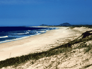
Myall Lakes National Park is a coastal wilderness spanning one of New South Wales' largest lake systems, with 40 km of beaches and towering sand dunes—unique terrain not found elsewhere in the state. The park offers whale watching from May to November, World Heritage-listed Gondwana Rainforest proximity, and over 4000 years of Worimi indigenous heritage at Dark Point.
Languages: English
Why go?
Myall Lakes National Park is a coastal wilderness spanning one of New South Wales' largest lake systems, with 40 km of beaches and towering sand dunes—unique terrain not found elsewhere in the state. The park offers whale watching from May to November, World Heritage-listed Gondwana Rainforest proximity, and over 4000 years of Worimi indigenous heritage at Dark Point. Unlike urban destinations, this park rewards those with their own transport and a taste for remote beaches, forest trails, and lakeside camping.
Adapted from Wikivoyage contributors · CC BY-SA 4.0
Get in
The park lies near Forster in the Mid-North Coast region of NSW, accessible via the Pacific Highway (A1). The nearest major city is Newcastle to the south, with Port Macquarie to the north; both are roughly 1.5-2 hours away by car. There is no public transport into the park itself—a private vehicle is essential. The entry point from the south passes through Bulahdelah, where you can stock up on supplies before entering the park.
Adapted from Wikivoyage contributors · CC BY-SA 4.0
Fees and permits
Park entry fees apply: $2.50 per pedestrian, $6 per vehicle, $6 additional for caravans/trailers/boat trailers, $5.50 per motorbike, and $10 for vehicles over 4 tonnes. Camping fees are separate and vary by campground; some basic sites have no extra fee beyond the park entry charge. Fees are modest compared to other NSW parks, but payment facilities inside the park are limited—bring cash or pay online where possible.
Adapted from Wikivoyage contributors · CC BY-SA 4.0
Get around
A car is strongly recommended given the park's vast size; all main roads are paved and in good condition. Four-wheel drives are permitted on beaches near Dark Point under certain conditions—destroying the surrounding environment is prohibited as Dark Point is a sacred Worimi site. Walking trails range from short 15-minute rainforest walks to the demanding 21 km Mungo walking track (10-12 hours one way). Cyclists can use the Mining Road to Old Gibber Road trail (20 km, ~6 hours). Do not attempt to cross the divided highway on foot.
Adapted from Wikivoyage contributors · CC BY-SA 4.0
When to go
Summer (December-February) brings warm temperatures of 19-27°C average maximum, but sand temperatures can be dangerously hot—avoid walking barefoot. Winter (June-August) averages 10-19°C; May-November is prime whale-watching season when humpbacks migrate past the coast. November is the driest month; May the wettest with up to 257.8 mm recorded in a single day. The park is busiest during school holidays, especially Christmas-New Year; Mungo Brush campground fills quickly then.
Adapted from Wikivoyage contributors · CC BY-SA 4.0
Where to stay
The park offers diverse accommodation from basic beachside campgrounds to heritage cottages. Mungo Brush campground (78 sites) is the largest but gets crowded in holidays; Broughton Island campground offers just 5 sites in an active seabird colony. For solitude, try Mackaway Bay (3 sites, requires 4WD) or Joes Cove (2 sites, accessible only by long walk). Heritage cottages like Cutlers Cottage overlook three lakes plus the ocean; Seal Rocks Lighthouse Cottages accommodate up to 20 guests in a heritage building near the lighthouse.
Adapted from Wikivoyage contributors · CC BY-SA 4.0
Food and drink
There are no cafes, restaurants, or shops within Myall Lakes National Park—bring all food and supplies from Bulahdelah or Forster. The park offers 10 designated picnic areas (Black Oaks, Engels Reach, Grandis, Hearts Point, Hole in the Wall, Northern Broadwater, O'Sullivans Gap, Pipers Creek, Tamboi, and Korsmans Landing) ideal for self-catered lunches. Tamboi picnic area requires boat access via the old wharf. Freshwater from taps at campgrounds is generally safe but bringing treated or bottled water is prudent for remote sites.
Adapted from Wikivoyage contributors · CC BY-SA 4.0
Things to do
Myall Lakes National Park offers kayaking on the lakes, swimming at beaches and bays, and guided paddleboard/kayak tours. The Mungo Rainforest walk (15-45 mins, Grade 3) is rich in birdlife—bring binoculars. The challenging 21 km Mungo walking track traverses most of the coastline in 10-12 hours. Broughton Island supports swimming, fishing, boating, snorkelling, and scuba diving. Cycling enthusiasts can tackle the 20 km Mining Road to Old Gibber Road trail (6 hours). Kayak and SUP rentals are available from external operators.
Adapted from Wikivoyage contributors · CC BY-SA 4.0
Stay safe
General safety is not a major concern in Myall Lakes National Park; wildlife poses minimal risk. The critical caution is walking barefoot on sand in summer—surface temperatures can be far higher than air temperatures and cause burns. Shark presence is a natural risk for swimming and water activities in coastal waters. Remote campgrounds have limited mobile phone coverage; inform someone of your plans before entering. Sun protection is essential year-round.
Adapted from Wikivoyage contributors · CC BY-SA 4.0
Connectivity
Mobile phone coverage is extremely limited throughout Myall Lakes National Park due to its remote coastal and forested terrain. Some areas near campgrounds and picnic sites may have intermittent reception from major carriers, but do not rely on connectivity. There is no public WiFi in the park. Download offline maps, inform contacts of your itinerary, and carry a personal locator beacon for emergencies. Power outlets are not available at campsites—bring spare batteries and a portable charger.
Adapted from Wikivoyage contributors · CC BY-SA 4.0
Go next
Head south to Tomaree National Park, or visit Forster and Booti Booti National Park nearby. Less than an hour away lies Barrington Tops National Park—a World Heritage-listed Gondwana Rainforest site and the closest such park to Sydney. The park lies on the A1 Pacific Highway route between Newcastle and Port Macquarie; Coolongolook and North Arm Cove are intermediate stops. Tourist Drive 6 continues northeast toward Taree via Forster.
Adapted from Wikivoyage contributors · CC BY-SA 4.0
Field guide adapted from Wikivoyage contributors · CC BY-SA 4.0. Text has been adapted and organized for this guide. About our sources.
Places to know
A few starting points from the guide. Check current hours and prices before you go.
- sleep
Banksia Green campground
15 campsites, although quiet since the sites are marked and unpowered. However, this would mean that you've more a beach to yourself.
Adapted from Wikivoyage contributors
- sleep
Boomeri campground
Another lakeside camping area. 20 campsites available.
Adapted from Wikivoyage contributors
- sleep
Brambles Green campground
Nice small, quiet camping spot by the Myall River. The only downside to this camping site is it can only facilitate two campsites.
Recorded price: No extra fees apply, but entry fees do
Adapted from Wikivoyage contributors
- sleep
Broughton Island campground
This is one of the few spots where you can legally camp in an active seabird colony. Apart from that, nearby activities in the sea include swimming, fishing, boating, snorkelling and scuba diving. While there's only five campsites here, it's for good reason - the island might feel like yours, as this isn't a well known campground.
Adapted from Wikivoyage contributors
- sleep
Cutlers Cottage
Small cottage, overlooking, not one, not two but three lakes, plus the ocean. 3 bedrooms, and maximum 6 guests allowed.
Adapted from Wikivoyage contributors
- sleep
Davies Cottage
A hillside cottage overlooking the ocean and right near Sugarloaf Point Lighthouse. 3 bedrooms, and maximum 6 guests allowed.
Adapted from Wikivoyage contributors
- sleep
Joes Cove campground
Only two campsites, and you will need to bring your items via a decently long walk. The water here also is not as clean as the water on the other side of the lake.
Adapted from Wikivoyage contributors
- eat
Black Oaks picnic area
Located on the southwestern banks of the Myall River, this picnic area is particularly known for a good place to go wildlife spotting.
Adapted from Wikivoyage contributors
Before you go
Accommodation
Options range from basic campgrounds (from $0 beyond entry fee) to heritage cottages accommodating up to 20 guests. Book ahead for school holidays.
Connectivity
Extremely limited mobile coverage throughout the park. No public WiFi. Download offline maps before entering.
Entry
Park entry fees: $2.50 pedestrian, $6 vehicle, $5.50 motorbike, $10 vehicles over 4 tonnes. Additional $6 for caravans/trailers.
Food
No food outlets in the park. 10 picnic areas available for self-catering. Nearest supplies in Bulahdelah.
Money
No ATMs, shops, or payment facilities exist inside the park. Bring sufficient cash and supplies from Bulahdelah or Forster before entering.
Safety
Avoid barefoot walking on sand in summer. Shark risk exists for water activities. Limited mobile coverage—inform someone of your plans.
Transport
A private vehicle is essential; no public transport serves the park. All main roads are paved. 4WDs allowed on beaches near Dark Point under conditions.
Weather
Summer averages 19-27°C but sand can burn. Winter 10-19°C. Whale watching May-November. Wettest month: May; driest: November.