
Beowa National Park
Oceania · Australia
See also
Overview
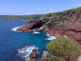
Beowa National Park (formerly Ben Boyd National Park) is NSW's southernmost national park, offering dramatic coastal cliffs, historic lighthouses, and some of the most secluded beaches on the Sapphire Coast. The park is famous for whale watching during migration season (May-November) and contains Aboriginal shell middens carbon-dated to 3,500 years old.
Languages: English
Why go?
Beowa National Park (formerly Ben Boyd National Park) is NSW's southernmost national park, offering dramatic coastal cliffs, historic lighthouses, and some of the most secluded beaches on the Sapphire Coast. The park is famous for whale watching during migration season (May-November) and contains Aboriginal shell middens carbon-dated to 3,500 years old. Unlike more developed parks, Beowa has no visitor center, limited facilities, and requires self-navigation—ideal for travelers seeking raw coastal wilderness.
Adapted from Wikivoyage contributors · CC BY-SA 4.0
Getting in
Beowa can only be accessed by car. The park has two unconnected sections with different entry points. To the northern section (Pambula-Haycock): 6 hr via A1 Princes Highway and Haycock Road from Sydney, 7 hr from Melbourne, 3 hr from Canberra. To the southern section (Green Cape): 7 hr from Sydney, 6 hr from Melbourne, 4 hr from Canberra via Edrom Road. Parts of the northern section north of the Pambula River can only be accessed via Pambula Beach.
Adapted from Wikivoyage contributors · CC BY-SA 4.0
Fees and permits
The northern section (Pambula-Haycock) is free to access. The southern section (Green Cape) charges $8 per vehicle. No other permits are required for day visits. Camping at Saltwater Creek campground and Bittangabee campground requires advance bookings via the National Parks website or phone.
Adapted from Wikivoyage contributors · CC BY-SA 4.0
Get around
The northern and southern sections are not connected by road—driving between them takes approximately 30 minutes via the highway. Within each section, a car is essential as distances are too great for walking. Roads in the northern section are mostly unpaved. In the southern section, only Edrom Road is paved; all other roads require 4WD after rain. Driving faster than 25 km/h may be difficult in the northern section after rainy months (February-March).
Adapted from Wikivoyage contributors · CC BY-SA 4.0
Where to stay
Accommodation exists only in the southern section. Options include Telegraph Station bunkhouse (max 4 guests, former 19th-century telegraph station), Green Cape Lightstation Keepers' Cottages (heritage cottages with lighthouse tours included), Saltwater Creek campground (14 campsites, bookings required), and Bittangabee campground (near swimming, snorkelling, diving, and birdwatching). The northern section has no accommodation whatsoever—campers must use facilities in nearby towns.
Adapted from Wikivoyage contributors · CC BY-SA 4.0
Things to do
Walking tracks include the Pinnacles loop (20-40 min, Grade 3), Pambula River walking track (short), Haycock Point to Barmouth Beach, Light to Light walk (multi-day), and various shorter tracks. Wildlife watching is excellent: Disaster Bay lookout offers views of beaches receiving fewer than 10 visitors daily, Green Cape lookout hosts resident fur seals, dolphins, albatross, gannets, and sea eagles, with muttonbird migration visible in October. Scuba diving spots exist near Terrace Beach (accessible by 4WD only).
Adapted from Wikivoyage contributors · CC BY-SA 4.0
When to go
The park is cold almost year-round, rarely exceeding 25°C. Whale watching peaks during May-November migration season. Holiday seasons bring slightly higher visitor numbers but the park remains uncrowded. Avoid February-March if possible due to difficult road conditions after rains. Book accommodations and campsites well in advance for holiday periods.
Adapted from Wikivoyage contributors · CC BY-SA 4.0
Safety
Wildlife is generally not a concern. Main risks involve remote access: bring adequate supplies, inform someone of your plans, and carry a first-aid kit. Road conditions deteriorate significantly after rain, particularly on unpaved northern roads—4WD with high clearance is recommended. Mobile coverage is extremely limited (see below).
Adapted from Wikivoyage contributors · CC BY-SA 4.0
Connectivity
Only Telstra has any coverage in the park, and it is sketchy in northern areas. Southern areas are worse, with large sections having no coverage at all. Optus and Vodafone have no coverage outside of Eden and Pambula. Do not rely on mobile data for navigation or emergency communication—carry a paper map and notify contacts of limited connectivity.
Adapted from Wikivoyage contributors · CC BY-SA 4.0
Go next
Head south to Mallacoota or north to Merimbula—both have basic services and better mobile coverage. To the west lies SE Forest National Park, home to one of the last remaining patches of pristine wet rainforest in the region. Eden and Merimbula are the nearest towns for fuel, food, and supplies.
Adapted from Wikivoyage contributors · CC BY-SA 4.0
Field guide adapted from Wikivoyage contributors · CC BY-SA 4.0. Text has been adapted and organized for this guide. About our sources.
Places to know
A few starting points from the guide. Check current hours and prices before you go.
- sleep
Bittangabee campground
The waters here are basically surrounded by recreation activities such as swimming, snorkelling and diving. If you're an avid photographer, there's some photographing opportunities here to take photos of birds.
Adapted from Wikivoyage contributors
- sleep
Green Cape Lightstation Keepers' Cottages
These heritage cottages provide stunning views of the ocean, and something that one can get never tired of. On top of that, guests that choose to rest their head here get a free tour of the lighthouse.
Adapted from Wikivoyage contributors
- sleep
Saltwater Creek campground
14 campsites. Bookings required on phone
Adapted from Wikivoyage contributors
- sleep
Telegraph Station bunkhouse
1 bedroom, max four guests allowed. But Telegraph Station bunkhouse was basically a former 19th century telegraph station which was later converted into accommodation.
Adapted from Wikivoyage contributors
- see
Barmouth Beach
This beach is not only popular for swimming, but it's also more popular for whale watching too. Barmouth Beach is also where George Bass first landed in December 18 1797. Picnic areas nearby. Parking available at Barmouth Beach Carpark.
Adapted from Wikivoyage contributors
- see
Bittangabee Bay ruins
These ruins are mainly some unfinished stone works that were built in the 1840s giving you a look at European history in the park.
Adapted from Wikivoyage contributors
- see
Boyd's Tower
This tower was built by Ben Boyd, although it was never commissioned as a lighthouse.
Adapted from Wikivoyage contributors
- see
Davidson Whaling Station
This whaling section explains how killer whales had helped the Davidson family. The ones that owned this whaling station. Apart from that, it is a historical site as well.
Recorded price: Free
Adapted from Wikivoyage contributors
Before you go
Food
No food, water, or supplies are available inside the park. Bring all food and water from Eden or Merimbula. There are no restaurants, cafes, or shops.
Money
Cash not needed inside the park as there are no services. Use Eden or Merimbula for any banking needs. The $8 vehicle fee for southern section is paid at self-service station.
Packing
Bring all food, water, and fuel. Carry a physical map. First-aid kit essential. Binoculars recommended for whale and bird watching. Good walking shoes required for tracks.
Transport
No public transport exists. A car is mandatory. Fuel up in Eden or Merimbula before entering the park. Northern roads are unpaved; southern roads require 4WD after rain.
Weather
Cold year-round, rarely above 25°C. Pack layers regardless of season. Rain can make roads impassable, especially February-March.